Advertisement
Not as often as most boaters might think. Find out how and when your electronic charts are updated with critical navigation information.
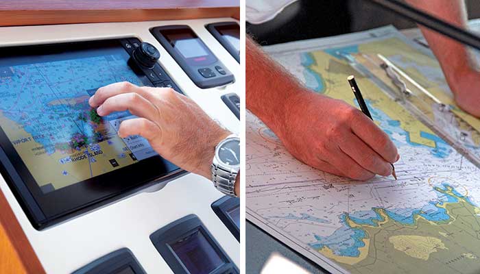
Today's robust chartplotters are a great navigation development from paper charts. But the lag time in updating their critical safety data is putting boaters at risk. (Photos: Billy Black, left and Getty Images/tcly, right)
The "nation's chartmaker," the U.S. Office of Coast Survey (OCS), is in the midst of a major strategic transition from printed nautical charts to electronic navigational charts, or ENCs. By 2025 the U.S. government will stop making print charts once and for all. For recreational boaters, this strategy is a good thing in many ways. Broadly, it promises much more detailed navigational information and quicker updates of what OCS calls "critical changes," like shoaling, dredging, hazards, and navigation aids that get moved, replaced, or eliminated. But in practice the transition from print to electronic charts has introduced several new problems that may be putting boaters systemically at risk.
Currently Corrected Charts
U.S. law requires commercial vessels to carry "currently corrected nautical charts and publications when operating in U.S. waters." Those publications include the latest "U.S. Coast Pilot," light lists, tide tables, and current charts. While those carriage requirements don't apply to uninspected recreational boats, they do reflect best practices for navigating safely, especially in unfamiliar waters.
The federal chart-carriage laws were established in 1951. From that time through the early 2000s U.S. hydrographic offices provided boaters a clear chain of products and practices to acquire and carry "currently corrected charts." The U.S. government delivered its best data directly to the skipper, with no private company in the chain. Every printed chart from the U.S. Government Printing Office included an edition number and date; the Office of Coast Survey (or, for many inland waterways, the U.S. Army Corps of Engineers) certified that the chart was corrected up to that date. Then, as critical changes occurred, the U.S. Coast Guard distributed weekly printed Local Notices to Mariners (LNM) announcing each of those changes. The skipper's best practice was to use LNM to correct charts from the present date back to the chart's printed date. The process was transparent and traceable, and the result was a "currently corrected chart."
In theory, today's transition to electronic charts simplifies this process and improves the quality of the information being updated. You can go to the OCS website at any time and download a currently corrected electronic navigation chart (ENC) straight from the source. Visit NOAA's Weekly Chart Update page to see which critical changes have occurred and when. You can go to the U.S. Coast Guard's Broadcast Notice to Mariners page to have all notices of critical changes for your region sent directly to your email inbox.
What's become more difficult, though, is to actually use those NOAA ENCs in the cockpit or nav station of your boat as you navigate in real time. Why? Because NOAA doesn't make chartplotters, and today's chartplotters for the recreational market aren't built to seamlessly run those freshly updated ENC cells directly from the official hydrographic office. The tried-and-true transparency and traceability of the older print system has been lost.
The Catch-22 Of Commercial Chartplotters
Here's a real-world example of the problem: In June 2021, BoatUS Member Richard LaPalme watched the Coast Guard change the buoyage system in his home waters around Beaufort, North Carolina. Red buoys replaced green buoys and vice versa, the numbers on many of the buoys changed, and some were eliminated altogether. In March 2022, LaPalme bought a 12-inch Raymarine Axiom Plus chartplotter for his Downeast-style Acadia 25 powerboat and installed Raymarine's LightHouse charts from the supplied SD card, which came with a one-year subscription for updates.
Advertisement
"When I installed the LightHouse cards, I noticed they did not have the updates for the changes that occurred the previous June," LaPalme said, which was nine months after the buoys were changed.
A boater for more than 20 years, LaPalme earned a U.S. Coast Guard Master license and teaches navigation with the U.S. Power Squadrons. Before he took up boating, he was a twin-engine flight instructor since the early 1990s.
"My background in navigation database updates goes back to my time as an IFR-certified pilot," he said, referring to Instrument Flight Rules for flying in restricted visibility. "There's no place to pull over at 10,000 feet."
LaPalme, an electronics engineer and military contractor who has worked with geographic information systems, bought the Raymarine chartplotter because he was so impressed with its hardware.
"We built a lot of gear for some very tough environments, and this is nice gear — really top-level stuff," he said. "You can tell they spent a lot of time thinking about the software and the menu system and how to provide quick access to familiar menu items that the sailor needs."
His beef wasn't with the chartplotter; it was with the charts. Using the Raymarine Charts Manager, Richard updated the Raymarine LightHouse charts two more times: first in May 2022, then again in July 2022. None of those charts represented the critical changes to Beaufort Harbor made in June 2021, more than a year before.
LaPalme discussed what he saw with other boaters. His friend Dave Aitken is a fellow boater who had also been bothered by delays he was seeing on his commercial electronic charts.
"The event that brought this concern to light," said Aitken, "was when the U.S. Coast Guard removed the first four ocean buoys from Beaufort Inlet and pulled the sea buoy named ‘BM' in a couple of miles."
Having noted that delay, he started taking notes regarding other local buoy changes the U.S. Coast Guard made in June 2022. The Local Notices to Mariners reported them on June 28. Fresh NOAA ENCs reflected the changes by June 28. Aqua Map reflected the changes by July 28. But by August 6, neither Raymarine's LightHouse nor Garmin's Navionics charts, though freshly updated, reflected the changes.
On August 10, LaPalme submitted a letter to the National Boating Safety Advisory Committee. "The safety of recreational boaters on the navigable waters of the United States is being jeopardized by the boaters' lack of access to up-to-date navigational charting information," he wrote of the recreational chart display information systems. "The displayed charts do not provide boaters any traceability to the U.S. Coast Guard-issued weekly Local Notices to Mariners. Recreational boaters have no way to know exactly how old the electronic chart is that they are viewing on their displays and what is the date of last incorporation of LNM data."
Tip
BoatUS asked manufacturers of some popular chartplotters to respond to LaPalme's letter.
"Is he off-base? No," said Dave Dunn, Garmin's director of marine sales. (Garmin owns Navionics.) "We will get there, I'm sure. But if you think about it, how many years did we use paper charts, and they weren't updated but every several years. Mariners should still know their waterways and pay attention to their surroundings. What he is asking, to push updates as often as the Coast Guard, that's tough."
How often does Garmin update Navionics charts with data the government hydrographic offices send out?
Garmin reports that it tries to integrate new data within 30 days from publication from the original source, Carly Hysell, Garmin's associate director of public relations says. "During the last couple of months, we have noticed a spike in new data releases from NOAA that we are working actively to process. ... For the particular case Mr. Aitken reported around Beaufort Harbor, we can confirm the update has been available on most of our products starting Monday, September 5." This was 70 days after the LNM reported those changes.
"LightHouse Charts are updated on an annual basis, or more frequently," said Raymarine marketing manager Jim McGowan. At press time on October 7, Raymarine reported that its LightHouse charts did not yet reflect the Beaufort changes, but they will be included in the fall 2022 updates.
BoatUS asked each manufacturer whether their charts' version numbers or issue dates corresponded to a particular LNM date and how each manufacturer recommends that boaters update their electronic charts to the standard implied by "currently corrected."
Advertisement
Navico Group, owned by Brunswick and including the C-MAP electronic chart brand as well as chartplotters under the Simrad, B&G, and Lowrance brands, would not share details or the timeliness of its updating process. But it did answer our question about whether carrying C-MAP charts aboard would satisfy U.S. chart-carriage requirements.
"All C-MAP charts covering U.S. waters are derived from official NOAA cartography and are updated with NOAA data," said Kim Rodriguez, global public-relations manager of Navico. "While C-MAP charts do not meet U.S Coast Guard carriage requirements for SOLAS-class and other regulated vessels, they can be used on leisure craft."
Raymarine LightHouse and Garmin Navionics charts don't meet U.S. carriage requirements, either. Each time a user switches on a Raymarine Axiom chartplotter, the following disclaimer appears: "This product is intended to be used only as an aid to navigation. It is the captain's responsibility to use official government charts, notices to mariners, caution, sound judgment and proper navigational skill when operating their vessel or using this or any other Raymarine product."
Given that the old, retired government-issued print charts, properly corrected, do satisfy U.S. carriage requirements, the question is: How can we meet our responsibility to use official government charts when the government no longer prints them, and the makers of commercially available chartplotters do not or cannot support the fresh ENC cells that the hydrographic offices produce?
Electronic Charting: A Glossary
- Broadcast Notice to Mariners (BNM): Like Local Notices to Mariners but delivered electronically. To receive them, go to navcen.uscg.gov and click on the BNMs tab. BNMs are also broadcast on the VHF Channel 22A.
- Electronic Chart Display and Information System (ECDIS): These displays comply with SOLAS chart-carriage requirements for commercial vessels. They typically display S-57 or S-63 encrypted data files from official hydrographic offices.
- Electronic Navigation Charts (ENC): Official ENCs for U.S. coastal waters are maintained and distributed by the Office of Coast Survey (OCS) under the National Oceanic and Atmospheric Administration (NOAA). The US Army Corps of Engineers (USACE) maintains and distributes ENCs for U.S. inland waters. S-57 is the standard NOAA ENC data format, available directly from a NOAA website. The S-63 format adds encryption. These charts are available only from "value-added resellers." Updated S-63 ENCs are today's gold standard for safe, encrypted, timely navigation information. For a complete description of NOAA's new electronic chart strategy, visit "Transforming the ENC" under the Publications tab on NauticalCharts.NOAA.gov.
- International Hydrographic Organization (IHO): The U.S. strategy for collecting and communicating navigational information, including ENCs, is being harmonized with that of other nations through IHO.
- Local Notices to Mariners (LNM): LNMs are the primary means for disseminating info concerning aids to navigation, hazards to navigation, and other items of marine information of interest to mariners on U.S. waters, its territories, and possessions. These notices are essential to all navigators for the purpose of keeping their charts, light lists, "Coast Pilots," and other nautical publications up-to-date. These notices are published weekly. Visit Navcen.uscg.gov and click on the LNMs tab.
- Multifunction Display (MFD): These are the electronic charting displays made for and marketed to recreational boaters that include a chartplotter function.
- National Oceanic and Atmospheric Administration (NOAA): Under the U.S. Department of Commerce, NOAA's mission is "to understand and predict changes in climate, weather, ocean, and coasts, to share that knowledge and information with others." The Office of Coast Survey comes under NOAA's direction.
- Office of Coast Survey (OCS): Within NOAA, the U.S. Office of Coast Survey (created by Thomas Jefferson in 1807) is "the nation's nautical chartmaker."
- The International Convention for Safety of Life at Sea (SOLAS): This maritime treaty, established in 1914, in response to the Titanic disaster, sets minimum safety standards in the construction, equipment, and operation of merchant ships. Its standards include those for ECDIS units on commercial ships but not uninspected recreational boats.
In Search Of A New Best Practice
BoatUS asked the chartplotter manufacturers whether they offer products for the recreational market that run "fresh ENC cells" directly from the official hydrographic offices, or if they see any time on the horizon when they will.
"Currently, today? No," said Garmin's Dave Dunn. "I can't comment on forward-looking plans, but I can tell you we are aware of those things, and we try to give customers as much of that stuff as we can."
"Raymarine Axiom products support S-63 secure, official chart data," said Raymarine's Jim McGowan. "S-63 charts are SOLAS-compliant, updated weekly, and certified for commercial applications. We are happy to work with customers or partners requiring these charts to meet official carriage requirements or [for those] wanting the most up-to-date navigational data available."
The latest Advanced Operation Instructions manual for Raymarine's LightHouse 4 system (04-2022 version) describes the installation procedures. To ensure security, S-63 files are available only from a "value-added reseller" and can only be read by a licensed owner. Although complicated and expensive, this process would almost solve the fundamental problem of carrying currently corrected electronic charts — but with one real-world gap.
"S-63 Encrypted Charts cells expire after a set period of time," reads a warning in the manual. "Once expired, the charts must not be used for navigation. You will be notified on screen of the expiration. The charts must be updated before they can be used for navigation."
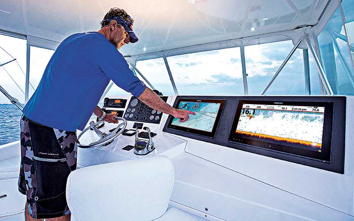
In home waters, where you know the territory well, you may think you can catch navigation changes yourself. But in new places, and often even in home waters, relying on charts that have not been updated is dangerous. (Photo: Billy Black)
Any transient boater who has chased ephemeral Wi-Fi or cell signals near the coast understands the fix he or she is in when that on-screen notification appears and the charts disappear altogether. "The S-63 process on a Raymarine Axiom multifunction display (MFD) must be done every week or the chart is no longer accessible," said LaPalme. "In my mind, a recreational update process would be far simpler and let the boater download the latest chart(s) whenever he wanted to, not forcibly every week. And NOAA offers the S-57 [digital vector] charts on its website for free."
Workable Backups
Boaters seeking currently corrected electronic charts do have several options apart from the offerings from the commercial MFD manufacturers. TIMEZERO, the company that makes the popular iBoat app for smartphones and tablets, also sells TZ Professional, which runs S-63 charts. This runs on a laptop or desktop computer with Windows software and shares the drawbacks of running S-63 charts on the Raymarine Axiom MFD.
Aqua Map is an app developed for smartphone or tablets. It's offered in a free version, with additional charges for chart-licensing fees. The Aqua Map Master app ($14.99 per year) has a "Download USCG data" function. With it switched on, Aqua Map updates all recent LNMs.
My partner and I installed a new Raymarine Axiom MFD on our Passport 40, Billy Pilgrim, in October 2021 before transiting the U.S. East Coast to the Bahamas and back to New England. In addition to our LightHouse charts, particularly in inland waters, we almost always had an additional iPad running TZ iBoat or Aqua Map in the cockpit. Having studied this update issue more carefully, in the event that our LightHouse charts differed from the Aqua Map charts, I would give preference to the likely more updated information given in the Aqua Map data — especially when navigating inlets, reefs, buoyed channels, and so on.
Open CPN is an open-source chartplotter software that's used by the U.S. Power Squadrons in its latest navigation classes.
"You can run it on laptops, notebook tablets, even Android and iOS systems," said LaPalme. "You can go directly to NOAA and download the government ENCs. Then you can set waypoints and do exactly what the other industry chartplotters do."
The drawback of such apps as a primary source for electronic charting may be the hardware, as anyone knows who has spilled coffee into a laptop keyboard. By and large, the manufacturers of recreational-use chartplotters and MFDs deliver high-quality robust hardware that can stand up to the harsh environments through which our boats often travel. It's just critical that we understand their charts' limitations.