Advertisement
Eight of the most compelling freshwater lakes around the country. Here's what makes each a fantastic playground for all types of boaters.
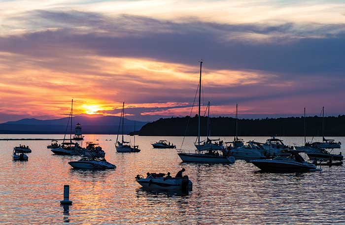
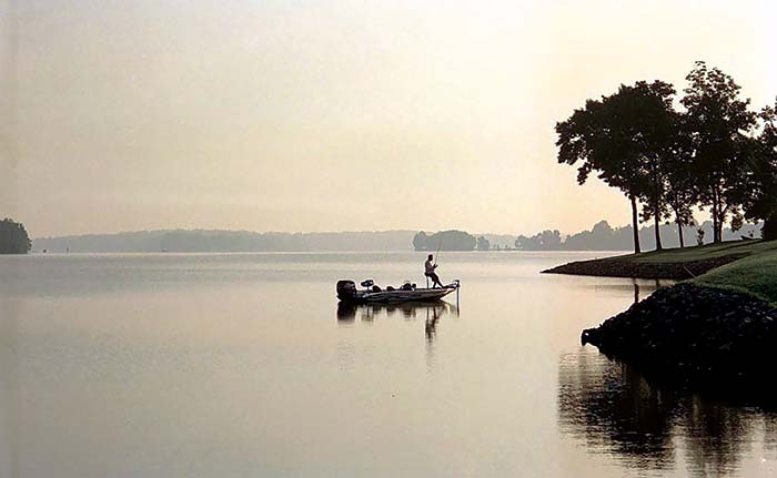
Photo: Thinkstockphotos.com
A few years ago, NASA used satellite photography to count 117 million lakes on earth, and the federal Environmental Protection Agency tallies 123,439 lakes in the continental United States alone. That's a lot of freshwater to play on, even if freshwater makes up only about 1 percent of all the planet's water bodies. When it comes to lifestyle choices, the fact is that while there are plenty of saltwater enthusiasts, given a choice, many boaters prefer freshwater — and for good reason. Lakes are kinder to your boat, offer different fish species to chase, are less prone to monster storms, maintain a consistent tide, and generally deliver greater tranquility.
With so many lakes, there's no way to rank "the best" in the U.S., and boaters tend to love their home waters for day-to-day fun. But some lakes are so special, they warrant a road trip with your trailered boat, or a fly-in for a visit and a boat rental or fishing charter.
In no particular order, here are eight lakes — other than the Great Lakes — that our editors love. Did we miss your favorite? Email us at Magazine@BoatUS.com.
Best freshwater lakes, according to BoatUS Editors
Lake Champlain
Vermont/New York
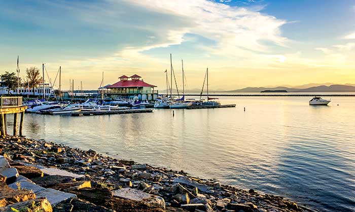
The Burlington Community Boathouse Marina on Lake Champlain in Burlington, Vermont, is a centrally located public dock with many amenities available. (Photo: Thinkstockphotos.com/Albert Pego)
Depending on how you measure it, it's about 120 miles from one end of Lake Champlain to the other. Straddling the border between Vermont and New York and stretching up into Canada, this freshwater lake, sometimes called the sixth great lake, stretches northward between the Green Mountains to the east and the Adirondacks to the west. There's all manner of boating on the lake, and although popular with the weekend crowd who come for the fishing, water skiing, and tubing, there's a distinct set of transient cruisers who traverse the lake in the spring and summer making their way to and from the Canadian Maritimes, thanks to canals that connect the lake to the Hudson River to the south and the St. Lawrence River to the north.
The lake played a critical strategic role in the American Revolutionary War era and was the scene of fierce fighting. Many of the 300 shipwrecks on the lake bed are from that era, but there are also shoreside reminders of the conflict; Fort Ticonderoga at the south end of the lake in New York is a popular tourist destination.
"The lake's unique," says Gayle Wilkerson, guest services manager at Apple Island Resort and Marina in South Hero, Vermont. "Many of the islands can only be visited by boat, and it's like stepping back in time. But if you tire of the natural beauty then a visit to Burlington is a must-do. You can dock in the heart of the small city, visit shops and restaurants, and take a stroll along the lakeside boardwalk." | LakeChamplainRegion.com
Location: Creates the border between Vermont and New York and extends across the U.S. border into Quebec
Size: 329,000 acres
Depth: 65 foot average, 400 foot maximum
Amenities: 18 marinas, 50 launch ramps
Fish: Wide range of species for year-round action including, rock bass, white perch, smelt, smallmouth bass, largemouth bass, northern pike, pickerel, muskellunge, Atlantic salmon, walleye, lake trout, brown trout, rainbow trout, sucker, carp, catfish, bullhead, bowfin, sheepshead, gar, sturgeon
Lake of the Ozarks
Missouri
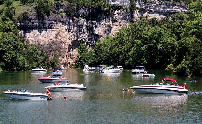
Boats 24 feet or less can dock on Lake of the Ozarks in Ha Ha Tonka State Park. Geologic features of this area include sheer bluffs, caves, a natural bridge, and a spring. (Photo: Missouri Division of Tourism)
Like a writhing serpent, Lake of the Ozarks winds through nearly 100 miles of Missouri and has dozens of inlets totaling 1,150 miles of shoreline — more than the California coast. It's never hard to find a secluded fishing spot. If you want more action, visit Anderson Hollow Cove, locally known as "Party Cove," a mile-long gathering spot that attracts an estimated 3,000 boats during summer weekends.
Tim Jacobsen, Executive Director of the Lake of the Ozarks Convention & Visitor Bureau says, "The lake was voted the 'Best Recreational Lake in the Country' by the readers of USA Today." Pleasure boating is very popular with more than 100 waterfront restaurants and lodging facilities, he says.
The Lake of the Ozarks Shootout is the largest unsanctioned boat race in the United States and is billed as the largest boating event in the Midwest. Fishing is big on the lake, too — hardly a weekend goes by that more than one fishing tournament isn't taking place. Paddlefish up to 100 pounds are not uncommon in the lake. Bringing your dog along? See how far he can jump at the annual Canine Cannonball competition held in Osage Beach each June.
Water temperature ranges from the mid-80s in the summer to the upper 30s in winter. One Lake of the Ozarks plus: Unlike reservoirs with water depths that may vary throughout the year, Lake of the Ozarks' depth is stable, meaning less worry about shallows and unknown submerged obstructions. | FunLake.com
Location: Central Missouri, about 40 miles southwest of Jefferson City
Size: 54,000 acres
Depth: 35 foot average, 90 foot maximum
Amenities: 63 marinas, 16 launch ramps
Fish: black and white crappie, bluegill, spoonbill, gizzard shad, channel catfish, white bass, walleye, gar, hybrid striper, largemouth and spotted bass. One of the largest paddlefish populations in the world
Lake Lanier
Georgia
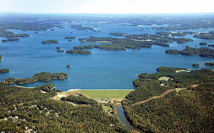
Lake Lanier is a reservoir created by the completion of the Buford Dam on the Chatahoochee River. (Photo: Thinkstockphotos.com)
Created in 1956 when the Buford dam was constructed across the Chattahoochee River, Lake Lanier has since become one of the principal playgrounds of nearby Atlanta. The south end of the lake is broader than the northern part and is closer to Atlanta, so it tends to get the most crowded especially during the summer months. Travel to the narrower northeastern end, however, and the crowds disperse with lots of secluded tree-lined coves in which to drop anchor. There are dozens of places to launch a trailer boat, but if you have something grander, then the lake has some of the largest freshwater marinas in the country, many with covered slips so you can keep your boat out of the sun. Temperatures reach the upper 80s in the summer and rarely drop below freezing in the winter, making Lanier a year-round boating destination.
Visitor bureau information officer for Lake Lanier and BoatUS Member Stacey Dickson says that draws lots of visitors to the lake. "In the summer there are spectacular fireworks displays and trophy bass fishing tournaments, but what I'm excited about this year is the international dragon boat racing championship that we will be hosting the second week of September."
"You'll find almost every type of watercraft on the lake, from sailing dinghies to humongous houseboats," continued Dickson. "There's a growing fleet of sailing boats that call the lake home with Wednesday night races and weekend regattas a popular year-round activity." | LakeLanier.com
Location: 30 miles northeast of Atlanta
Size: 37,000 acres
Depth: 50 to 60 foot average, 156 foot maximum
Amenities: 13 marinas, 100 launch ramps
Fish: spotted bass, largemouth bass, white bass, crappie, catfish, red-breast sunfish, red-ear sunfish, green sunfish, warmouth longnose gar, carp
Lake Havasu
Arizona
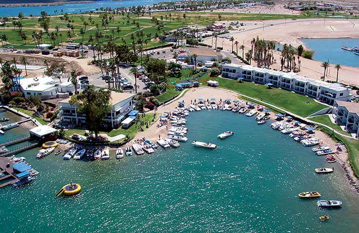
Leave your boat right outside your room at Nautical Inn Resort on Lake Havasu. (Photo: Lake Havasu City Convention & Visitors Bureau)
Year-round boating and 300 days of sunshine each year draws boaters near and far to this 25-mile-long man-made lake on the Colorado River at the Arizona/California border. Despite being located in both the Mojave and Sonoran deserts, Havasu's coastline features a striking landscape of both sand dunes and towering rugged mountains carved by the Colorado River, with hundreds of little coves to park in.
Water temperatures generally range from the low 50s (F) in winter to the 80s in summer. The lake serves as the playground for pontoons, wakesurfers, go-fasts, and kayakers, and is rated one of the top 20 best bass fishing lakes in America for small and large mouth by Bass Master Magazine.
"You name it we have it. There's something for everyone," says Jim Salscheider, president of the Lake Havasu Marine Association. "Boaters also love us for our clean water. Since we're on the Colorado River and there's a constant flow, our water turns over every two to four weeks." The river also offers an added bonus — 35 miles of navigable river past the north end of the lake, most of which is a tranquil National Wildlife Refuge.
Beyond the desert locale, the lake has two more distinctive features. Scattered around the shores are 26 miniaturized replica lighthouses, modeled after iconic lights such as Cape Hatteras and Chicago Harbor. The lake is also home to the historic London Bridge. Yes, the 930-foot granite bridge built in the 1830s across London's Thames River. The wealthy founder of Lake Havasu City paid to dismantle it, ship it to Arizona, and rebuild it. The span now serves as a link between the mainland and the marinas, eateries, and watering holes on what is known as "the island," a former peninsula that was carved off to create a passage for boats, named the Bridgewater Channel. | GoLakeHavasu.com
Location: Lake Havasu City on the border between California and Arizona
Size: 619,000 acres
Depth: 35 foot average, 90 foot maximum
Amenities: 6 marinas, 16 launch ramps
Fish: striped bass, largemouth bass, smallmouth bass, channel catfish, flathead catfish, sunfish, carp, red ear sunfish (world record)
Lake Travis
Texas
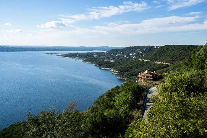
The rolling hills on the western edge of Austin overlook Lake Travis.
Often called the "Crown Jewel" of Texas highland lakes, and situated about 18 miles northwest of Austin in the heart of Texas, Lake Travis was formed in 1942 when the Colorado River was dammed at an old river crossing at Marshall Ford to prevent flooding downstream. In recent years, the lake levels had been significantly lowered due to drought, but recent reports show levels are coming back to normal.
As you'd expect of a southern lake, there's year-round boating with temperatures in the upper 80s during the summer and rarely dropping below mid 40s in the winter, although higher temperatures are frequent. The size of the lake depends on whom you talk to, but it's considered to be about 65 miles long and 4.5 miles from shore to shore at its widest point.
There are four distinct areas of the lake:
North Shore is the less commercial side of the lake, known for secluded getaways with fantastic amenities, beautiful marinas, and wonderful vacation rentals.
South Shore, the most commercial area and closest to Austin, has the greatest selection of amenities.
Spicewood on the west side. Although there are many amenities, it retains an old-school feel.
Volente on the eastern side is home to many marinas, boat rentals, and lake-fun amenities.
Hippie Hollow Park on the shore of Lake Travis offers spectacular landscape views, but it's best known as the only legally recognized clothing-optional public park in the state of Texas. Navigating Travis Lake requires some care as there are large sand bars and steep drop-offs that catch unwary boaters, but watch the depth and there's plenty to explore and with lots of places to launch, moor, and dock your boat.
Like many inland lakes in the U.S., Travis has become infested with zebra mussels. So, if you're taking your boat to and from the lake, make sure to wash properly, clean, and dry your equipment. Visit BoatUS.org/Invasives to learn more.
The last word goes to Laura Mitchell, President of Lake Travis Chamber of Commerce: "There's lots to do on the water, but we're close to Austin, the state capital. If you tire of aquatic adventures, head downtown where we have winning restaurants and a thriving arts scene." | LakeTravis.com
Location: Austin
Size: 18,622 acres
Depth: 62 foot average, 210 foot maximum
Amenities: Many lakeside lodging options, 23 marinas, boat rental facilities, 17 boat ramps, campgrounds, picnic areas, fishing, parks, shopping, restaurants
Fish: Largemouth bass, Guadalupe bass, white bass, striped bass, catfish (blue, channel, & flathead), crappie, sunfish
Lake Norman
North Carolina
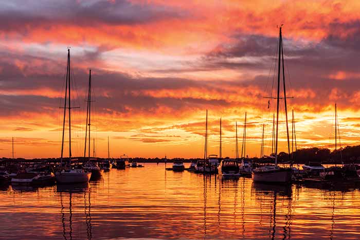
A fiery sunset over Lake Norman, North Carolina's largest lake, which is located just 20 miles from Charlotte. (Photo: Visit Lake Norman)
Lake Norman was created in the 1960s as a byproduct of an energy-producing hydroelectric dam in central North Carolina. Today, the reservoir is the largest man-made body of freshwater located in the state, and one that caters to on-the-water fun. Marinas, fishing guides, vessel rentals, and tourist cruises can be found around the sprawling lake with more than 520 miles of coastline, much of it from the numerous coves and nooks that surround the lake.
The fleet of recreational boats is diverse: runabouts, wakeboats, bass boats, daysailers, pontoons, kayaks, paddleboards, and, since there's no horsepower or speed limit on the lake, some go-fast boats. It all works because there's room for everyone on the 34-mile lake and plenty of quiet coves, even on busy weekends. Food, entertainment, and service facilities ring the lake, known locally as the "inland sea" of North Carolina. "Nothing beats a beautiful leisurely sunset cruise, whether heading to one of Lake Norman's many well-known waterfront restaurants or just drifting in the breeze," says Travis Dancy, sales director for the tourism group, Visit Lake Norman. "There are also many boat raft-up meeting points on the weekends, where you will find numerous boats of all variety rafted up together having a great lake time."
State fishing licenses can be purchased online at N.C. Wildlife Resources Commission. | VisitLakeNorman.org
Location: About 20 miles north of Charlotte
Size: 32,750 acres
Depth: 25 foot average, 110 foot maximum
Amenities: 8 marinas, 8 public boating access areas, 2 yacht clubs, 2 bank fishing areas
Fish: catfish, crappie, bluegill and yellow perch, striped bass hybrids, freshwater gar
Smith Mountain Lake
Virginia
Boating is one of the most popular activities on Virginia's Smith Mountain Lake. (Photo: Smith Mountain Lake Chamber of Commerce)
Known locally as "SML," Smith Mountain Lake is the second largest lake in the state. Created in the 1960s when the Roanoke River was dammed to help prevent downstream flooding and provide hydroelectric power, the resulting lake covers more than 32 square miles, and thanks to the many bays and islands, there's more than 560 miles of shoreline to discover.
Before heading out onto the lake, a visit to one of the several visitor centers located around the shore is a good idea, one of which is conveniently located near Parrot Cove Boat Rentals and launch ramp, where Route 122 crosses the lake just south of Roanoke.
Water levels remain consistent year-round thanks to the runoff from the omnipresent Blue Ridge Mountains to the north. Water temperatures are in the mid-70s in summer, dropping to the low 40s during the winter months, making boating a distinct year-round possibility. No one sort of boating dominates on the lake, so whether you're a fisherman, cruiser, or sailor, you'll feel right at home here.
According to Annette Stamus, Marketing and Communications Manager for Smith Mountain Lake Chamber of Commerce, there's tons of reasons to visit the lake. "We have the cleanest water on the East Coast, and there's so much happening in and around the lake all year. Our busiest time is between Labor Day and Memorial Day, but there's lots going on outside this time, too."
In April, there's the Bassmaster Classic tournament, and in late September the Virginia Island Sailing Association holds a sailing regatta. A popular attraction is the annual antique and classic boat show every September, now in its 28th year.
"Lots of folks come for a one-time visit and end up coming back year after year," says Stamus. "They just can't get enough of this lake." | VisitSmithMountainLake.com
Location: Moneta, about 30 to 45 minutes from both Roanoke and Lynchburg
Size: 20,600 acres
Depth: 55 foot average, 250 foot maximum
Amenities: 6 public and several private boat ramps located at many of the 20 marinas
Fish: Black bass (largemouth and smallmouth), striped bass, crappie, catfish, sunfish, muskie, and others. Virginia fishing license required
Shasta Lake
California
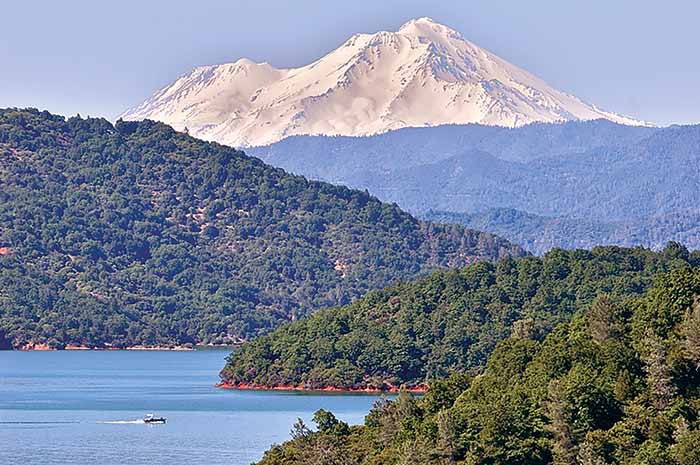
Lake Shasta boaters can drink in the view of Mount Shasta's 14,000-foot snowcapped peak.
If boating in the shadow of a perennially snowcapped 14,180-foot mountain sounds enticing, Shasta Lake in northern California is for you. California's largest reservoir, created by damming four rivers, has 365 miles of mountainous shoreline. Four steep evergreen- and manzanita-covered arms stretch dozens of miles north and east with enough room to get away from the crowds. Summertime water temperatures in the upper 70s help keep you cool during the occasional 100-degree days. Wakeboarding is a serious sport on the lake, and fisherman, water-skiers, PWC riders, and houseboats share the cool, clear water. Kayakers can explore miles of hidden coves.
Joe Stubbendick, acting recreation staff officer for the Shasta-Trinity National Forest, says that there are over 1,100 houseboats on the lake, many available for rent. Fishing is a big draw, too. "The best fishing starts in January, and because the lake is at a fairly low elevation, the winter climate here is mild enough for year-round use," he says.
While you're there, don't miss the Shasta Dam. At 602 feet, it's the second-largest concrete dam in the country, and you can tour it for free. It's said that a visiting Woody Guthrie sang "This Land is Your Land" to a group of migrant workers building the dam back in the 1930s. | ShastaLake.com
Location: Redding, 160 miles north of Sacramento
Size: 30,000 acres
Depth: 157 foot average, 517 foot maximum
Amenities: 9 marinas, 7 launch facilities
Fish: rainbow trout, brown trout, chinook salmon, largemouth bass, smallmouth bass, black crappie, bluegill, carp, white sturgeon