Advertisement
The idea of a water connection between Cape Cod, Massachusetts, and Buzzards Bay is 400 years old this year – first proposed in 1623 by Myles Standish, the military commander of the Plymouth Colony. Its location was obvious even then: In the isthmus valley between the mainland and the cape, where the Manomet River led south into Buzzards Bay and the Scusset River led north into Cape Cod Bay, later to be dug out by the canal.
The relatively short land portage between these rivers is where the Pilgrims chose to build their Aptucxet Trading Post in 1627 to barter with the Dutch and Native Americans. Dutch traders would sail up from what is now New York into the Manomet, while the Pilgrims would sail down from Plymouth into the Scusset, and trade at the land bridge at Aptucxet. Commerce, convenience, and safety were why the site was selected.
Humanitarian reasons for digging a canal there would be added in later years as commerce grew and countless ships and lives were lost trying to navigate the treacherous and often foggy shoals of Outer Cape Cod. More than 1,000 shipwrecks lie in the Atlantic breakers just between the towns of Truro and Wellfleet on the arm of the cape. In the late 1800s, Cape Cod claimed a ship roughly every two weeks.
Official governmental interest in a canal began in 1697 with consideration of proposals, but no action was taken. Over the next two centuries numerous surveys, recommendations, and false starts would be made. Compared with other famous canals of the era, Cape Cod’s came late in the game. Even during the heyday of canal building – the Erie Canal opened in 1825, the Suez Canal in 1869, work on the Panama Canal began in 1881 – serious work on a canal for Cape Cod wouldn’t begin until 1909. Why the long delay?
Robert Farson, in his history of the Cape Cod Canal project says it was “probably that the motivation for building other canals was primarily commercial, while the principal reason for a Cape Cod canal was humanitarian – to save lives.” Without government sponsorship, the staggering toll of shipwrecks and death didn’t matter unless the canal could turn a profit. In 1914, finally, after several years of hard labor, the canal was opened, and the rest is history.
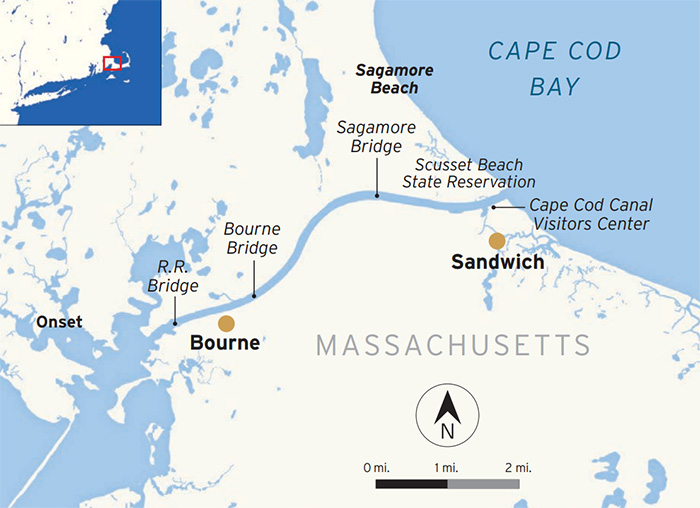
Illustration: U.S. Army Corps of Engineers, New England District
No longer the long way around
To many who cross it today, the Cape Cod Canal is just a frustrating traffic jam. There are only two highway bridges that span this man-made waterway, and both are old, narrow, and jammed with traffic on summer weekends. The throngs of impatient tourists who drive here each season see the canal both as the gateway to the cape and as a roadblock to their fried clams, ice cream, and beach vacation. But to anyone on the water, the canal is a beautiful, curving, essential, and sometimes challenging shortcut for all kinds of small boats, big commercial ships, and military vessels navigating between Buzzards Bay to the south (and the Mid-Atlantic coast), and Cape Cod Bay to the north (and the upper New England coast).
It’s also popular with fish, and the canal’s banks get crowded with anglers during a striper run, and trophy bass and haddock can also be landed. It’s not unusual to spot much larger sea life, including sharks, and even the occasional North Atlantic right whale, in the canal.
Before this land cut was made across the isthmus of the cape, countless ships were wrecked and lives lost in the vicious storms and deadly sandbars of the Outer Cape – once one of the deadliest passages on the entire Eastern seaboard. The canal shaves off about 135 miles from going around the outside of Cape Cod. Even with the advent of railroads and highways, Cape Cod Canal today remains one of the most important and still-active artificial waterways ever constructed in the United States, transited by some 15,000 vessels every year. Fuel for New England – gasoline, oil, jet fuel – is the primary freight that passes through.
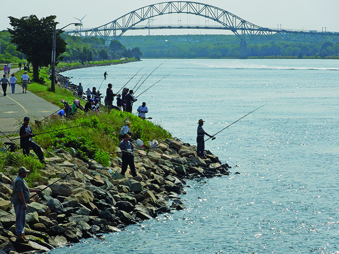
Photo: Kevin Burke
By the numbers
Cape Cod Canal, at only 7.4 miles, is not the longest canal in the world, but it is the widest – 540 feet at its maximum point – for which it’s listed in the Guinness Book of World Records. The canal is owned and maintained by the U.S. Army Corps of Engineers and has no tolls.
The sea-level waterway runs roughly east-west, with a minimum channel width of 480 feet and a controlling depth of 32 feet at mean low water. Tidal currents here are strong, sometimes hitting 6 mph, and change every six hours. Ebb tides run westerly toward Buzzards Bay; flood tides run easterly toward Cape Cod Bay.
Only powered vessels capable of handling the current are allowed in the canal. Sailboats with auxiliary power will need a fair tide to get through. If it’s not clear already, reading and understanding the tide tables here is essential.
High tide in Cape Cod Bay is higher than in Buzzards Bay, so the strongest currents tend to run on the ebb – flowing east to west. The hydrodynamics of the bend in the canal on the east end can be a tricky spot even for big ships. In my first passage years ago, at the helm of a 35-foot sailboat riding a strong ebb tide toward Buzzards Bay, I was surprised how easily the powerful crosscurrents and standing waves pushed us around. Wakes from passing boats and ships can bounce off the stone riprap on either side of the canal, sometimes creating a lateral “slosh effect” that greatly amplifies the watery chaos.
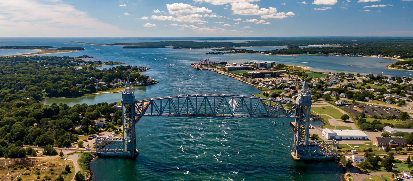
Both of the fixed highway bridges that cross the canal have 135 feet of vertical clearance: The Bourne Bridge is close to Buzzards Bay on the west end, while the Sagamore Bridge is close to Cape Cod Bay on the east end. The canal’s beautiful vertical-lift railroad bridge, near the mouth to Buzzards Bay, also has a 135-foot clearance when raised, but only 7 feet when down. A bridge closure is announced by two long horn blasts.
There is only one place inside the canal for recreational boats to stop: at the East Boat Basin located on the south side of the Canal (Sandwich Marina), which has a boat ramp and limited slips for transients. Boaters on the west end of the canal by Buzzards Bay can wait out the tides on the mainland side at Taylor Point Marina in Bourne (take the Buttermilk Bay channel) or by anchoring or mooring at the charming town of Onset. On the cape side, Phinneys Harbor near Monument Beach is a popular anchorage near the canal for transients.
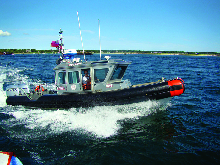
A canal patrol boat keeps boat traffic in line. Left: Retired tugmaster captain Bill Brucato advises recreational boaters to “keep your distance and let the big boat go first.” Photo: Bill Brucato
Transiting the canal
The two biggest dangers to recreational boaters here are swift currents and encounters with large commercial traffic in a narrow channel. The ships and barges always have right of way over recreational boats in the canal because they have deep draft and cannot stop or quickly maneuver.
Coming up from Buzzards Bay, you approach the canal from Cleveland Ledge Light along Hog Island Channel. At the start of the land cut to port is the Massachusetts Maritime Academy – its wind turbine is a prominent landmark – a small but highly ranked public university established in 1891 to provide deck and engineering officers for the merchant marine. About a half-mile east of MMA is the canal’s railroad lift bridge. A mile farther east is the Bourne Bridge, where Route 25 crosses the canal. A mile-and-a-half more, as the canal begins its curve to the north, are the big overhead power cables that supply Cape Cod’s electricity. Another mile and a half brings you to the Sagamore Bridge and Route 6, followed on the cape side by the Canal Generating Plant (the major landmark on this end of the canal), Sandwich Harbor, and finally the breakwater into Cape Cod Bay. The Army Corps’ Canal Visitors Center is located near Sandwich Harbor and well worth a visit.
How long is the canal?
An online search will catch references to the Cape Cod Canal as either 7.4 or 17.4 miles. Don’t be confused. The Army Corps of Engineers is responsible for dredging 5 miles of approach on both ends, which they define as “the canal.” As far as boaters are concerned, the land cut is 7.4 miles.
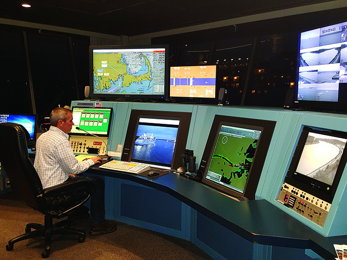
Staff at the marine traffic control center monitor the entire length of the canal every minute of every day. Photo: USACE
Traffic control
The nerve center of the canal is a small white building next to the railroad lift bridge on the mainland side. This is the U.S. Army Corps Marine Traffic Control Center – the canal’s version of an air traffic control tower – which monitors all activity in the canal 24/7.
Anytime you’re in the canal, you’re being watched. Powerful cameras and radar arrays are mounted on bridges and elsewhere along the canal, giving controllers the ability to monitor every inch of the waterway and far out in the approach lanes to the canal. A big bank of computer screens displays those images, real-time tidal and weather data, and other information (such as AIS ship identification icons) inside the MTC center.
Marine traffic controllers are highly trained to manage the constantly changing traffic, weather, tides, and potential for disaster. It’s a high-stress, high-stakes job sometimes calling for instant decisions involving huge freighters, car carriers, cruise ships, megayachts, and fuel barges, all sharing space with countless smaller recreational and fishing boats.
The Army Corps MTC is responsible for controlling all large commercial shipping, not just in the canal, but also in two other sectors: from the entrance of Buzzards Bay to Cleveland Ledge Lighthouse south of the canal, and from Cleveland Ledge through the canal and into the Cape Cod Bay approach channel. It also operates and maintains two hurricane floodgates in the area at New Bedford, Massachusetts, and Providence, Rhode Island.
Help at hand
Boaters headed to the west end of the canal can get real-time reports on local conditions from:
- TowBoatUS Cape Cod/Plymouth, VHF Ch. 9 and 16, and by phone at (508) 295-2226.
- Army Corps of Engineers Marine Traffic Control Center in the canal, VHF Ch. 16, and by phone at (978) 318-8500.
Boaters looking for a respite or mechanical aid can find it here:
- Sandwich Marine (east end), sandwichmarina.com
- Taylors Point Marina (west end), (508) 759-2512
Local knowledge & canal etiquette
Susan McDonald, a civilian marine traffic controller for the Cape Cod Canal, says one of the most common mistakes recreational boaters make is trying to transit the canal with a motor that’s too small.
“If you don’t have the horsepower, we’ll have you turn around and get to where you can anchor and wait for a favorable current,” she says.
Other mistakes include going too fast, operating on the wrong side of the canal (“Stay to the starboard side.”), bow-riding, and stopping or swimming anywhere in the canal. Something that will get you written up: Trying to beat the railroad lift bridge once it starts to come down. It’s dangerous, and you’ll get a fine.
In his years of taking family and friends out on the water, Matt Kravitz, a school principal who fishes and lobsters in his spare time, has learned to treat the canal with deep respect because of the strong currents, wakes from passing boats that bounce off the riprap and create confused waves, and other fishing boats that often ignore speed limits and basic rules of seamanship.
“It’s not a very boat-friendly area,” he notes. If striped bass are running in the canal on “commercial days” (when individual fishermen with commercial licenses crowd the waterways), there can be a wall of boats off the end of the canal buoys waiting for the fish to come through. “I’ve seen boats stacked up outside the mouth of the canal, and the commercial guys can get very brazen and belligerent. It gets colorful – a lot of shouting and name-calling – a real rodeo.”
A special threat, he says, is fishermen on the banks of the canal. Big ships with deep draft tend to disturb the bait fish, so game fish (especially stripers) will jump at the bow or stern as the vessel passes through. Fishermen will cast aggressively for that, regardless of what’s in the way.
From the perspective of the commercial ships, recently retired tugmaster Capt. Bill Brucato says the secret to a safe canal passage is to “keep your distance and let the big boat go first. Twenty thousand tons of steel and gasoline headed down your way and you don’t want to move over? That’s kind of crazy.”
But it’s not all doom and gloom. If you know what you’re doing and are careful, Kravitz says the beauty of Cape Cod’s waters (including the canal) is irresistible. He will never forget the time in 2021, late in the day and shortly before a storm came in, when he was outside the Sandwich breakwater of the canal helping his 13-year-old daughter, Senja, who has a student commercial license, haul her lobster pots, when a North Atlantic right whale swam up to their boat.
“Senja was at the helm and immediately went to neutral. The whale spent a lot of time swimming sideways around us, showing its tail flukes, going after the fish,” Kravitz recalls. “It was a magical moment.”
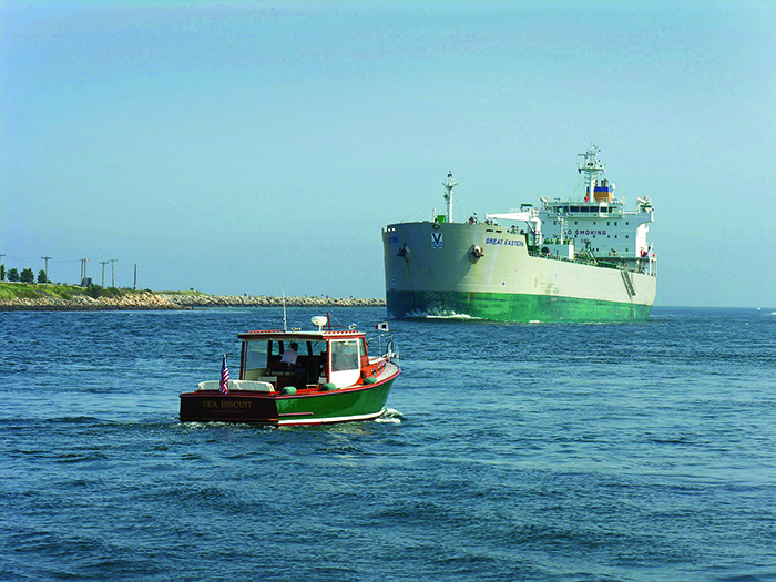
Have you ever seen a massive tanker ship up close? You will inside the Cape Cod Canal. Photo: USACE
A challenging passage
Recreational boaters can get in trouble anywhere, but in the Cape Cod Canal the most dangerous place is at its mouth into Buzzards Bay. If a strong ebb tide running out of the canal (flowing southwest at almost 6 mph) coincides with a strong prevailing afternoon wind (blowing northeast up the bay at nearly 30 mph), the opposing wind-against-current creates a classic sea-state nightmare: big, sharp, or even square waves; viscous chop; potentially deadly conditions. More than a few boats have capsized or sunk in this area — and some lives have been lost — when wind and tide decide to fight it out here.
Matt Kravitz, who lives in East Sandwich and launches his 23-foot fishing boat out of Sandwich Marina, usually sticks to Cape Cod Bay. But on the rare occasions when he heads the other way into Buzzards Bay during the summer, he knows to pay extremely close attention to both the wind and tide before he leaves the dock.
“Buzzards Bay is a funnel at the top and can become a trap. The predominant wind is from the southwest, and with a strong ebb tide from the canal dumping lots water against the wind, it creates these standing 6-foot rollers — or worse,” Kravitz says. “If you’re not prepared for that, it’s dangerous.”
James Deal, an experienced Army Corps patrol boat operator in the Cape Cod Canal, says the West Approach Channel (also known as the Hog Island Channel) can become a death trap for inexperienced boaters who aren’t expecting the survival conditions that can suddenly develop when a strong wind and strong current are in opposition.
“I’ve seen 10- to 12-foot breaking waves at the west end of the canal,” Deal says. “A couple of years ago, a 22-foot cuddy cabin motorboat with a family on board went into those conditions, and the boat capsized. Eight people went into the water. One child didn’t make it out.”
He adds: “There have been and will continue to be close calls in the canal.” — S.B.